Bicycle travel throughout Thailand is pleasurable for many reasons. The frequent and plentiful food stalls, the ubiquitous roadside salas (wooden-roofed bus stops), and the friendly disposition of the Thai people towards foreign travelers are a few reasons that come easily to mind. Another reason that makes Thailand such a great cycling destination is its highly developed infrastructure. Thailand’s road and highway system is significantly more developed than those in neighboring countries. While knowledge of this system’s signage may appeal mostly to those cyclists interested in long-distance touring, a basic understanding of the information available on Thai road signs could prove beneficial to all bicyclists.
In this first installment of what BicycleThailand.com plans to make a recurring monthly article we will address the Thai highway system’s kilometer markers. These white stone markers preceded all metal signage on the roadways and perhaps because of this reason they seem to be more accurate with regards to kilometer distances than some of the metal signs that have recently been placed alongside them.
Here is a basic explanation of what the kilometer markers are telling you. It is useful information whether you can read the Thai script or not.
Every stone marker has four (4) sides. The side parallel to the Highway or Road is the face side. The side that you see first as you approach the marker (remember that in Thailand we are all riding on the left side of the left-hand lane) we will call the arrival side. The side that you will see if you look back over your shoulder after passing a stone marker we will call the departure side. The back side of the stone marker is always blank unless an aspiring grafitti artist has left their mark.
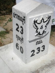
Photo 1 – On the face side of the stone marker is the Highway or Road number contained within a birdlike outline. This is the number of the Highway or Road you are traveling on. It will correspond directly to all printed Thai road maps. In this photo the stone marker is on Highway 4. In Thailand it is not uncommon for a Highway or Road to also have an actual name in addition to its number. It is best to reference to Thai maps utilizing the number rather than the name of a Highway or Road due to frequent inconsistencies.
Below the Highway or Road number is the Thai script for the letters K and M. Essentially this equates to KM = Kilometer
Below the Thai script for KM is a number. This number is the number of kilometers that this specific stone marker sits away from the origin of the particular Highway or Road. In this photo the stone marker is exactly 233 kilometers distance from where Highway 4 begins (Hwy 4 begins in Bangkok).
On the top of the arrival side of the stone marker is the name of the next city of noteworthy size. This can be referenced to a Thai map. If you are unable to read the Thai script simply match the symbols. Below the city name is the city’s distance, in kilometers, from this specific stone marker. In this photo the city of Pranburi is 23 kilometers away.
Below the first city’s kilometer distance is the name of the next city of noteworthy size that lies beyond. This second city also has its distance, in kilometers, written below its name. In this photo the city of Kuiburi is 60 kilometers away.
This two city listing makes food, water, and rest stops much easier to plan out.
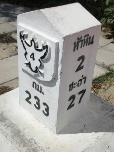
Photo 2 – On the top of the departure side of the stone marker is the name of the closest city of noteworthy size in the opposite direction you are traveling (you’ve probably ridden through this city already). Below the city name is the city’s distance, in kilometers, from this specific stone marker. In this photo the city of Hua Hin is 2 kilometers away.
Below the first closest city’s kilometer distance is the name of the next closest city of noteworthy size in the opposite direction you are traveling (maybe you rode through this city too!) This second closest city also has its distance, in kilometers, written below its name. In this photo the city of Cha Am is 27 kilometers away.
In order to illustrate how the numbers on the stone markers change I set out on a grueling two-kilometer ride and photographed the next stone marker that I found along the highway.
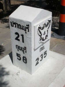
Photo 3 – As you can see the face side of the stone marker still shows the Highway number, Highway 4, but the kilometer distance has changed. Now we are at a stone marker that sits exactly 235 kilometers from where Highway 4 begins (Bangkok).
On the top of the arrival side of the stone marker the name of the next city is still Pranburi but the distance to that city has now changed (decreased) to 21 kilometers.
Below the first city’s kilometer distance is still the name of the city that lies beyond Pranburi. But now the distance to Kuiburi has changed (decreased) to 58 kilometers.
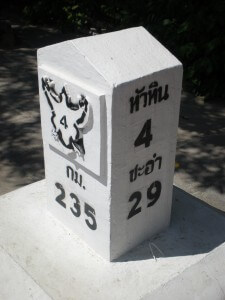
Photo 4 – Likewise, on the top of the departure side of the stone marker the name of the last city is still Hua Hin but the distance to that city has now changed (increased) to 4 kilometers.
Below the first city’s kilometer distance is still the name of the city that came before Hua Hin. But now the distance to Cha Am has changed (increased) to 29 kilometers.
We hope this short description proves helpful to you in your travels. Happy riding!
Planning a cycling trip in Thailand? Want to remove some of the guesswork when it comes to routes and information? BicycleThailand.com offers GPS route data for touring cyclists that can be used on a GPS device, smartphone, or tablet. These routes can be viewed on your device regardless of internet access during your Thailand cycling adventure. Learn more about our Thailand GPS cycle touring routes.


Leave a Reply