Jump to content


Photo

Bicycle Riding On The Chantaburi Coast


  • Please log in to reply
28 replies to this topic

#1 Ulysses N. Owen

Ulysses N. Owen

    Advanced Member

  • Members
  • PipPipPip
  • 205 posts

Posted 19 August 2011 - 03:25 AM

Coastal Chanthaburi is maybe the most bicycle-friendly part of Thailand? On the mainland roughly between Koh Samet and Koh Chang the coast road has been developed with brad new red-colored cycle lanes on each side. Sure they still get used at times by slower motorbikes, but the colored lanes, the signposting - and how about that 'bicycle parking' - is a big step up from anywhere else I've been riding in Thailand. Cycle-friendly indeed. There's plenty of cyclists in this area of Thailand; lots of active 'mature' Thais out on bikes, a mix of road/race bikes and big frame MTBs with road tires, groups from Chantaburi Burapha University, mix of male and female, and also a University MTB group we've seen heading into the surrounding hills.

Posted ImageWe've been at the bus station in Chanthaburi city (30km to Chao Lao) and seen people coming/going with their bikes on the bus, nice weekend away for low-key touring, a backpack and some good accommodations at Chao Lao for 500b a night, less if you just want a fan room and no air conditioning. For more low-key riding, several of the beach resorts rent bicycles by the day/hour. The best I've seen is from the store in Chao Lao with the ATM machines and gas station; about three months ago they bought eight new MTBs for hire.

Apart from the cycle-lane roads there are so many other routes with little traffic and good scenery, all that's missing are hills if that's what you want, it's basically flat and changing gears doesn't happen too often, best hill is a small, steep one at the south end of Chao Lao beach.

Posted Image

Things to see along the way

Laem Sing - small coastal fishing village. There is accommodation here, some seaside restaurants, and an ATM machine.
Laem Sing beach - many kilometers of white sand beach, isn't the best for swimming May-October (especially the northern end) as too close to the river mouth and tends to be brown from silt carried down the river.
Kuk Khi Kai - built by the French Army in 1893 when this was French occupied territory and used to imprison Thai rebels; known as 'chicken dung cell' as chickens were kept on the grated roof above the prisoners.
Tuek Daeng - 'the red building' was once French military barracks, later used as a library/museum now locked up and unused.
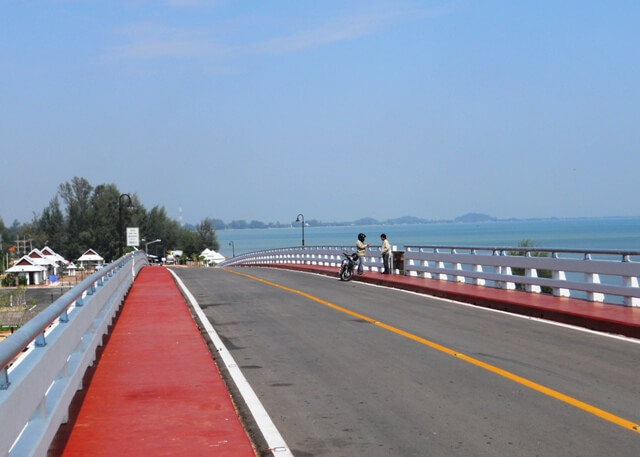
Laem Sing (Great King Taksin or Taksin Maharat) Bridge - opened May 2008, before then it was either ferry across or a 60km drive; good views on a clear day inland towards the hills of Namtok Phlio National Park in the distance.
Chaopho Laemsing Shrine - Chinese shrine about 400m west of the northern end of the bridge.

Posted ImageOver the bridge and continuing north along the coast, options to turn left to Ao Yang and or Ao Krathing, two secluded bays with safe swimming beaches. There is cheap accommodation at Ao Krathing and Ao Yang, 400b per night. Other than that, the next 10km or so is a simple road, all-flat, along the coast, 20-50m from the sand. Easy to spot the two temples on top of the few hills in the area, both about 1km inland; one is a 240-step climb and unfortunately what would once have been a fantastic view is now mainly obscured by trees. The second is still under construction, the golden Buddha is visible from a long way off, and a road leads almost to the top of the hill, good views of the coast and surrounding countryside.

Back on the main road and you're at Pak Nam Khaem Nu and the site of the second recently built bridge, which will take you over the hill to the south end of Chao Lao beach. At the south side of the bridge is a new rest area and site of the 'bicycle parking area' - nice spot at the river mouth to take a break in some shade. Another option is to head inland from here to Tha Mai - 12km, and another 12km from there to Chanthaburi city.Posted Image

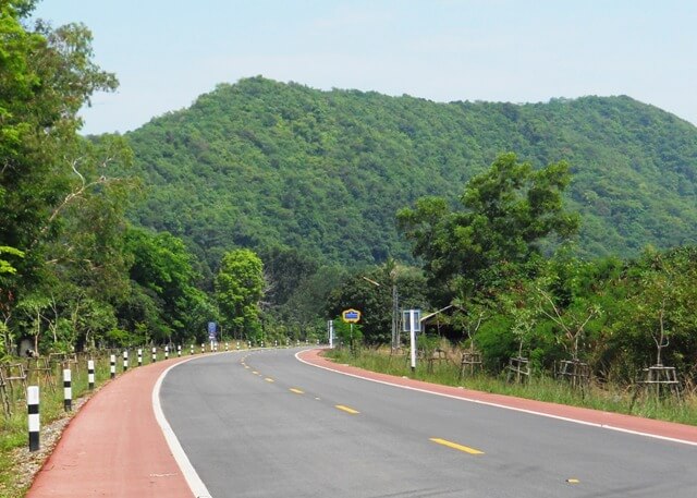
Over the bridge heading north, at the end of the bridge you'll see a beached boat that has been converted to a cafe, and a road that heads off to the right, following the river to Khlong Khut and Burapha Chanthaburi University campus (about 10km).

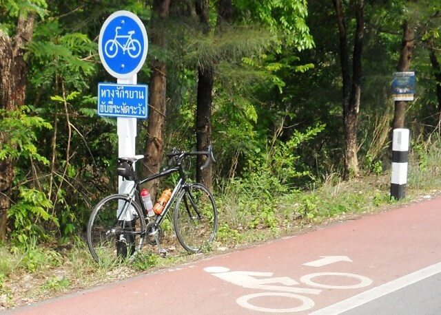
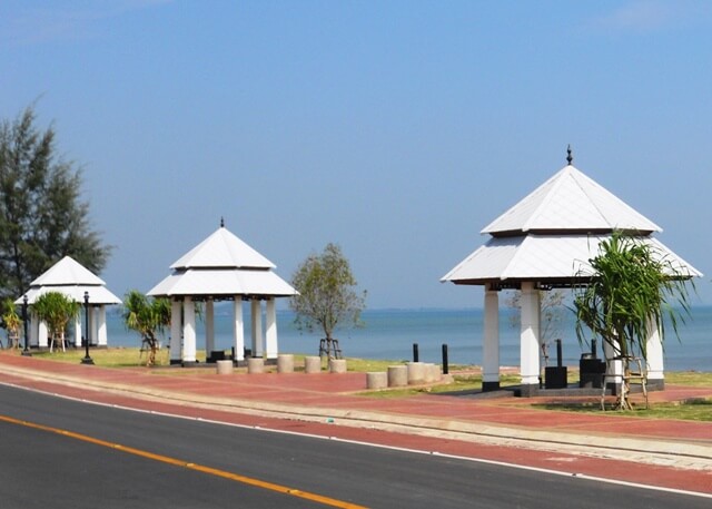
Better to follow the marked cycle lanes, turn left towards the river mouth and over the hill, a tight right-hand corner and the steepest hill on the coast road, for me using my lowest gear. About 50m before reaching the flat road there's a track down to the left that gives access to a reef and a reasonable snorkeling area for beginners when conditions are good. Chao Lao beach is 5.5km long. Plenty of accommodation here if you choose to stay. Fan rooms advertised from 300 baht. This area is very popular with Thais, especially on weekends and school holidays. Halfway along the main road there's a big general store next to the gas station, two ATMs, chalet accommodation for 500/night.

Continuing on through Chao Lao township - there's about 2km of cycle lane separated from the road by a median strip, on the sea-side of the road - you'll reach the dugong roundabout, this is Ban Mu Dud in memory of the dugongs that were once common in the estuary but now all but extinct.

Continue straight ahead to Laem Sadet, about 2km, where the road ends, you're now on a point of land with estuary to the right/east, and Laem Sadet beach to your left/west side

A few things to see here

The aquarium, part of a marine research center. Well-kept and maintained, hugely popular with school groups, and . . . there is no admission charge. Free. There is a donation box if you feel the urge to donate.
Laem Sadet beach - popular with surfcasters/beach fishermen, but swimming is ok in calm weather only; it is a 'shelf' beach, very steep, deep very quickly and often unsuitable for swimming - especially at this time of year. Several 'no swimming' signs - if you do want a swim head at least 1km south where it's safer.
Khung Kraben Bay Royal Development Study Center is based across the road from the rear of the aquarium. It monitors the extent and degree of mangrove destruction over recent decades to make room for large-scale shrimp farming, develops restoration strategies, and launches rehabilitation programs. Entry is free.

As for traffic - the busiest road is the section from Thai Mai through to Chao Lao and Khung Wiman - 17km and while I've never seen an accident, they do go fast, traffic increases from 10am on weekends as people travel from Chanthaburi city, best avoided for cyclists.

Khung Wiman (various spellings, Koong Viman, Kung Wiman)
Heading out of Chao Lao, at the dugong roundabout follow the red cycle road inland - can't go directly north on the coast here due to the estuary; there is a minor road also, but the main one is an easier ride, about 4km and you'll come to an intersection that gives the option of going north to Khung Wiman and beyond, or inland to Thai Mai 12km and on to Chanthaburi city a further 10km.

Continue along the road 5km toward Khung Wiman and there's another roundabout - dolphins/loma this time. There's a big drivers' rest area under construction here, maybe completed Jan/Feb 2012. Turn left and head for the coast, all flat except for the final hill a few hundred m before the shoreline. At the base of this hill there is also a road off to the right/north where the cycle lane continues.

Khung Wiman (north side)
Small beach about 200m, ok for beginners snorkeling off those rocks, not too deep. There's a couple of seaside restaurants - food cooked on the inland side of the road and brought to you in the little bamboo huts, some modern, and not-so-modern resort-style accommodation. At the end of the road is a boat ramp, and Al Medina Beach House, a Moroccan-styled guesthouse that's quite a surprise to see in this area.

Khung Wiman (south side)
On this south side route there is a 5km loop road that follows the coast then back along the estuary.Posted Image
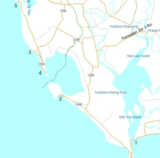
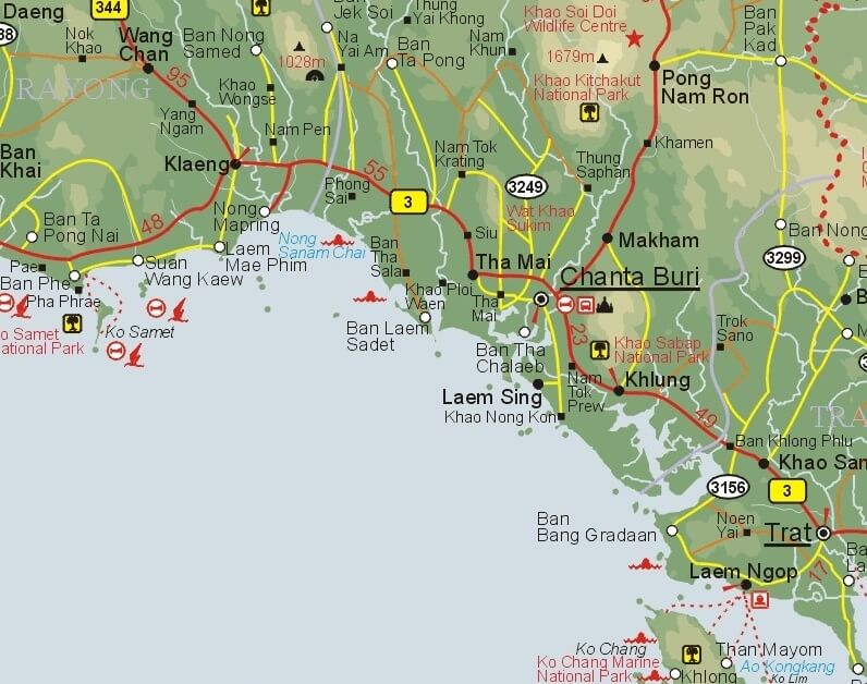
Refer to the map at right for these points, numbers 1-5 refer to:


    [*]Bridge over the hills to south end Chao Lao; best swimming usually about 1/2 way between points 1 and 2
    [*]Laem Sadet and Khung Kraben
    [*]Khung Wiman north
    [*]Khung WIman south
    [*]Na Sa & Khlong Ta Pon

The main beach at Khung Wiman is aprroximately 1km long. Some waterfront restaurants here, continue along the flat and up the hill. The hill - both sides - was once sealed but now a mess, rutted and potholes, on a road cycle best to walk, ok on an MTB. On the sea-side of the road you'll see a Buddha facing out to sea; turn left opposite this statue and it's a one-way road (going the wrong way but don't worry) which takes you to a good lookout point and another statue, views on a clear day.

Posted ImageContinuing along you'll get a view south and of the estuary, and facing south you can see the hill on the other side that shelters Laem Sadet. It's a 14km ride here around the estuary, all flat apart from a couple of hills, but in straight line only 2km from Laem Sadet - as the crow flies. The road loops back through clusters of boat fishermen's houses and exits back on the road into Khung Wiman, 5km in all.

Heading north from Khung Wiman the red cycling lane continues, but there is 'not much to see here.'

Rubber tree plantations, fish farms, after about 6km there is Na Sa, a fishing village, the beach here is more like mudflats, not a white sand beach, and unsuitable for swimming. The next good beaches would be south of Ban Phe another 30+ km away.

Some notes for people doing this trip:

*Laem Sing and Chao Lao have the only ATMs along this route.

*The last section of red cycle lane over the hills at south Chao Lao was completed very recently.

Article and photos by Atmos


#2 Paul Hamon

Paul Hamon

    Advanced Member

  • Members
  • PipPipPip
  • 133 posts

Posted 21 August 2011 - 07:27 AM

i want i want i want.

Regardless of why you ride a bicycle, you arrive at your destination feeling relaxed and energized!


#3 Atmos

Atmos

    Member

  • Members
  • PipPip
  • 24 posts

Posted 10 September 2011 - 01:51 AM

We went to the Khung Kraben Bay Royal Development Study Center on Tuesday this week, interesting place, no entry fee; there is a raised walkway for 1.6km through the mangroves and an observation tower for watching wildlife/birds; they have volunteer days for planting mangrove seedlings to improve the habitat for fish/crabs, and hopefully one day re-establish the dugong colony there – sadly the last dugong was sighted in the bay April 2006.


From October 15 to April 15 they rent out double kayaks for 100b per hour, short paddle through the mangroves then out into the bay, it is approx 3.5km x 2.5km, sheltered with just a narrow entrance into the open sea.


There is a small resort/guesthouse 'Chanthaburi Boutique' being built near the entrance to the bay (follow the road another 1km) looks like it will be complete by Xmas, would be a great place to stay right on the waterfront, small cafe restaurant next door, boat trips for snorkeling/sightseeing, and they also rent out kayaks though unsure of price.

Posted Image

Posted Image

Posted Image

Edited by Atmos, 01 March 2013 - 03:45 PM.


#4 Ulysses N. Owen

Ulysses N. Owen

    Advanced Member

  • Members
  • PipPipPip
  • 205 posts

Posted 13 September 2011 - 01:55 AM

Thanks for your great post Atmos. We look forward to many more

#5 Atmos

Atmos

    Member

  • Members
  • PipPip
  • 24 posts

Posted 13 October 2011 - 05:06 AM

Rides/tours on this coast road 

Sunday 9th we were headed the other way, saw a group headed by a scooter in a Specialized vest, and followed by a pickup with Specialized  logos on the doors, ride organised by the dealer in Chan city, shop diagonally opposite Big C shopping centre and I'd recommend it, owner/manager very involved in local cycling; and they serve good coffee too.

 Posted Image Posted Image

Today 12th a bigger group – not locals – about 20 of them – with support vehicles, heading south along coast road towards Laem Sing where we'd just been.  Of course too busy to stop (us and them)

Posted Image

Edited by Atmos, 01 March 2013 - 03:02 PM.


#6 Atmos

Atmos

    Member

  • Members
  • PipPip
  • 24 posts

Posted 01 March 2013 - 08:06 PM

Each year mid-February Chanthaburi has events commemorating the end of French Army occupation in 1906, based around Laem Sing where the main French force was based (their barracks and small prison are still standing near the river entrance)

Highways are lined with the red/elephant flag that was the flag of Siam at that time.

Some pics from a ride last February

Posted Image Posted Image


One thing that is noticeable from my first photos here is how the red asphalt marking the cycle lanes has faded to a pale pink. The cycle lanes on the main bridge crossings at Paknam Kahem Nu and Laem Sing have been repainted, but in the areas where road is in full sun the cycle lanes looking rather washed-out.

#7 Atmos

Atmos

    Member

  • Members
  • PipPip
  • 24 posts

Posted 01 March 2013 - 08:15 PM

On Sunday 23 Feb the annual 'Love 2 Wheels' coast ride was held, 73km round trip from Khung Wiman south to Laem Sing and return, all on the red (pink!) cycle lanes of the Chaloem Burapha Chonlathit Coast Highway

Unfortunately due to a recent accident i was unable to take part. 

One of the pics here shows the CBC route, marked in red, over 100km in all of (relatively) safe cycling


Posted Image

Posted Image

Posted Image

Posted Image

Posted Image

Posted Image

#8 Atmos

Atmos

    Member

  • Members
  • PipPip
  • 24 posts

Posted 01 March 2013 - 08:25 PM

Posted Image

Posted Image


Pleased I don't live in Chan city and can avoid the worst of the traffic; this pic is at the Tak Sin Intersection 4km west of the city and is a popular route to the coast; I prefer not to ride that strip of road before 9.30am, or after 4pm, in the interests of self-preservation, this pic was an after-work Wednesday evening ride.

Last week i saw two heavily-laden tourers at this intersection while I was heading in to the city at 7.30am. Nightmare stuff, everyone in a hurry, merging lanes, I'd have recommended they wait 2 hours for a more relaxed ride.

#9 Atmos

Atmos

    Member

  • Members
  • PipPip
  • 24 posts

Posted 01 March 2013 - 08:36 PM

a note on maps

the two major bridges at Paknam Khaem Nu and Laem Sing were both completed about 2008-09. Before then the options were either boat, or head a long way inland for an eventual bridge crossing.

Recently we have encountered tourers, on a solo, and a couple, with out-dated maps that did not show either bridge. 

The solo man, German, looked rather depressed when i explained he'd added an unnecessary 40km to his ride by heading inland then back to the coast

'but there is no bridge on my map'

it was a reprint, but not updated, from 2001.

Anyone else meet a couple from Argentina last year? Traveling on this tandem with 15mth boy in the trailer, when we met them they'd covered 12,000km in Asia and here heading north of Chanthaburi and across into Cambodia at Ban Laem. They traveled amazingly light, very little luggage, and on a very tight budget (tenting at the beach, seen here at Laem Sadet)


Posted Image

Edited by Atmos, 07 April 2013 - 04:44 AM.


#10 Ulysses N. Owen

Ulysses N. Owen

    Advanced Member

  • Members
  • PipPipPip
  • 205 posts

Posted 11 March 2013 - 11:28 PM

Atmos!   We applaud you on your constant updates of what is occurring (cycling-wise) on the Chanthaburi coast. We cannot wait to come and re-visit that wonderful area of Thailand ;-)   Keep up the great updates.   All the best, The BicycleThailand.com Team

#11 Atmos

Atmos

    Member

  • Members
  • PipPip
  • 24 posts

Posted 05 June 2013 - 08:40 PM

I saw the thread 'Kung Wiman to Baan Prasae' on this forum (http://www.crazyguyo..._id=274474&v=47) and in Mrch finally got around to doing the ride, slightly different in that we started about 8km south of Khung Wiman, at Chao Lao Beach, and did a 'there and back' ride.

Posted Image Posted Image

Chao Lao beach, and the start point, the 7/11 store by the roundabout at north end of Chao Lao


Posted Image Posted Image

It's an easy route - stay on the red (pink in places!) cycle lane and follow the signs with the ship on them - several big ones over the road show a picture of the navy ship at our destination, Prasae.

Edited by Atmos, 05 June 2013 - 04:41 PM.


#12 Atmos

Atmos

    Member

  • Members
  • PipPip
  • 24 posts

Posted 05 June 2013 - 08:46 PM

Chao Lao - Prasae (Part 2)

Posted Image Posted Image Posted Image


While it follows the coast, there are few spots where the sea is visible, most of the way there are small hills between road and sea, and we're riding through rubber tree plantations on hill slopes and fish/prawn farms on the flat. Less than inspiring scenery, and as far as 'scenic route' goes, about a 5/10 for me. But good road all the way, little traffic (we went on a Saturday), no shortage of places to stop for water/snack food as well as the little highway shelters/rest stops along the way.

A very flat ride - easy to cruise along and barely needed to change gear; one person I rode with was on a Turbo Cobra - 2,490 baht from Tesco-Lotus - trouble free and fine for a leisurely ride. It's not all about the price! they're solid bikes and ideal for the 'family rides'.

Posted Image Posted Image

There's always a 'this is Thailand' moment, and this one made me laugh. When we got to Prasae we saw this new road which had yet to have the roadmarkings done, so off we went, very quiet with no other traffic, beautiful as it goes over a mangrove plantation towards the river/coast where we were headed. then it stops. No we didn't try to carry bicycles down the ladder! back we went and took the 'old' route. The new road will cross the river and continue the coast highway - complete with red cycle lanes, towards Rayong, and (who knows) a worker said the bridge over the river would be finished 'next year'. At present to get across, either take a boat, or ride inland and back down the other side of the river, adds about 8km to the journey.

Edited by Atmos, 05 June 2013 - 04:56 PM.


#13 Atmos

Atmos

    Member

  • Members
  • PipPip
  • 24 posts

Posted 05 June 2013 - 09:04 PM

Chao Lao - Prasae (Part 3)

Posted Image

At Prasae, well, not too much to see - the local attraction is the HTMS Prasae which was dragged ashore and made into a tourist attraction in 2003.
A little bit of history here: USS Gallup a Tacoma-class frigate, was built in California and launched 1943; US Navy in the Pacific until 1945; transferred to Soviet Navy as EK-22 ; returned to US Navy 1949 and recommissioned 1950 for duty in the Korean conflict; transferred to the Royal Thai Navy 1951 as HTMS Prasae; preserved as a memorial at Sattahip Naval Base then towed to Prasae 2003 as The HTMS Prasae Memorial

Posted Image Posted Image Posted Image

Some views from Prasae waterfront near the rivermouth. There's a mangrove 'park' nearby with raised boardwalk, and . . . not much else. I expect that will change when the highway comes through here, the bridge will cross about 300m from the rivermouth and bring a lot more traffic to the area.

So off home we went. I try to avoid 'there and back' rides but no option today.

#14 Atmos

Atmos

    Member

  • Members
  • PipPip
  • 24 posts

Posted 05 June 2013 - 09:15 PM

Chao Lao - Prasae (Part 4) the ride home

Heading home. About half-way between Chao Lao and Prasae there's a series of signs advertising 'Museum 4km'. They're also on Sukhumvit 3 the main highway which is further inland. About 2 years ago we went to see this museum, followed signs all the way, and yes, a building, empty.

Posted Image
Surely 2 years later they'd have finished?

Posted Image Posted Image Posted Image

So we made the diversion through narrow little rural roads, some welcome shade on what as a typically hot day, sheltered by towering rubber trees each side of the road. Arrived at the museum, set on land built out into a lake. Very scenic. the building remains empty. Nothing to see here . . .on your bike.

Maybe another 2 years?

And back to Chao Lao. Time for a swim.
Trip distance about 41km each way, plus the bonus 8km to an empty museum if you're keen!

#15 Atmos

Atmos

    Member

  • Members
  • PipPip
  • 24 posts

Posted 05 June 2013 - 10:10 PM

Chan Coast - Roadside rest areas - Sa Nam Chai

Posted Image
Posted Image
On the coast road between Chao Lao and Kung Wiman, the rest area at Sa Nam Chai is about 200m south of the dolphin roundabout, turn here to KW beach. Shaded areas, toilets, a coast map, and often there are markets here late afternoon

Posted Image Posted Image Posted Image

Edited by Atmos, 05 June 2013 - 06:14 PM.


#16 Atmos

Atmos

    Member

  • Members
  • PipPip
  • 24 posts

Posted 06 June 2013 - 12:08 AM

Chao Lao beach - low tide riding

Not for everyone - sand!! saltwater!!

Posted Image Posted Image

About 5.5km each way, at the southern end, the first 2km or so are more mudflat than sand and a few axle-deep water crossings. You WILL get wet!

Posted Image

Mind your head on the pier it is only about 1.6m above the sand

Posted Image Posted Image


Posted Image
Back on solid ground, the bridge at Paknam Khaem Nu - over the hill from south end Chao Lao beach.


10km return, or as I do, a diversion from the Thai Mai/Paknam Khaem Nu/Chao Lao/Tha Mai 40km loop

Edited by Atmos, 05 June 2013 - 08:09 PM.


#17 Atmos

Atmos

    Member

  • Members
  • PipPip
  • 24 posts

Posted 06 June 2013 - 03:32 AM

Chan Coast – Roadside rest areas – Laem Sing

Posted Image Posted Image
Laem Sing is a good place to stop for a break, and this small park/rest area is about 20m from the sand of LS Beach, food vendors and restaurants. For me I have a choice of a 56 or 71km route from home, across the edge of Chan city to Laem Sing is 35km, pedal along the coast and either turn inland before Paknam Khaem Nu (56km ride) or over the hill and through Chao Lao (71km ride)

It is easy to nod off (and snore, i am told), in one of these shelters.

Posted Image
This one on the beach, is often populated by groups/families having lunch. I don't like Laem Sing beach for swimming, being directly in the outflow of the huge Chanthaburi River it is often a murky brown and unappealing.

Posted Image
Over the Laem Sing bridge heading north, Paknam Khaem Nu about 10km, over another bridge and another 4km to Chao Lao

Posted Image
And here, about 8km north of Laem Sing heading towards Paknam Khaem Nu, this small park area by the beach offers some shade. No good for swimming here though, outfalls from the many fish/prawn farms make the water very unpleasant

Edited by Atmos, 05 June 2013 - 11:40 PM.


#18 Atmos

Atmos

    Member

  • Members
  • PipPip
  • 24 posts

Posted 24 June 2013 - 10:40 PM

Chan Coast – Roadside rest areas – Paknam Khaem Nu (south side) http://i1221.photobu...zps0101fc3d.jpg http://i1221.photobu...zpsb6fd53b1.jpg http://i1221.photobu...zpsb5e762d2.jpg The first (and oldest, 2011) of the major rest areas on the Chaloem Buraphja Chonlathit Highway, the Paknam Khaem Nu area is currently being expanded to provide some more sheltered areas and some wonderful fish sculptures reflecting the local fishing industry. http://i1221.photobu...zpsdb0ad8d7.jpg About 15km ride from Laem Sing, the other big bridge on this coast. Flat ride all the way on marked cycle lane, about 20-30m from the sea. Not much to see along the way, look inland and a couple of temples on hills are visible and an easy detour to visit, hilltops offering good views of the surrounding area. http://i1221.photobu...zps8d79269a.jpg At Paknam Khaem Nu, rest area on the sea side at south end of bridge, markets here in late afternoon and an adequate little restaurant - and of course good options for fish/prawns on the menu.

Edited by Atmos, 24 June 2013 - 06:45 PM.


#19 Atmos

Atmos

    Member

  • Members
  • PipPip
  • 24 posts

Posted 24 June 2013 - 10:57 PM

Chan Coast – Roadside rest areas – Paknam Khaem Nu (north side) http://i1221.photobu...zpsbadd40d0.jpg http://i1221.photobu...zpsfbdd44ec.jpg Over the bridge, and stop to take in the views - about 4pm the local fishing fleet goes out to sea. I've mentioned before this bridge does not appear on some maps - opened 2009, and when we first went through here in May 2010 the road either side, and about a further 10km north, was unsealed/clay. Since completed in asphalt with marked cycle lanes all the way. Crossing the bridge on the cycle lane can be difficult as at times there will be too many fisherman and their rods blocking the way. http://i1221.photobu...zpse0920abd.jpg http://i1221.photobu...zps29643cf3.jpg http://i1221.photobu...zpsa1e44000.jpg Immediately over the bridge heading north there is an option to go inland - 9km along the side of the estuary/river to Khlong Khud. But most people follow the main road, about another 2km and you're at the Khung Kraben Non-Hunting Area (Conservation) a headland with a public camping area. Gets busy long weekends, public holidays but generally quiet. The little shop only opens at busy times. There are toilets, a large covered dining area, and grassed area for tents under the trees, right at the water's edge. http://i1221.photobu...zpsd3a47f68.jpg http://i1221.photobu...zpsecd404f0.jpg http://i1221.photobu...zps97195d83.jpg http://i1221.photobu...zps09650329.jpg There's a couple of small bays here OK for a swim when the tide is in, can be rocky when the water's out. There are marked walking trails in the hills, signs notifying of pythons (thanks! but we haven't seen any) and an easy walk to the hilltop for views. For food, water etc options are back to Paknam Khaem Nu, or head over the hill about 4km to Chao Lao (nearest ATM is here too)

Edited by Atmos, 24 June 2013 - 07:04 PM.


#20 Atmos

Atmos

    Member

  • Members
  • PipPip
  • 24 posts

Posted 11 July 2013 - 01:09 AM

Short rides from Chan city 1 - The Road to Tha Chalaep Starting point for these rides Eastern Hotel, opposite Big C (supermarket/cinema/shopping centre), easy to get to near the lake and all the locals will know where they are. Opposite Big C there's an excellent cycle shop, Specialized dealer, also hires out cycles, owner very involved in local cycling and organising family/social events as well as more serious racing. Recommend them for any repairs/maintenance/spares they've been very good to me. http://i1221.photobu...zps54e2dae3.jpg The ride to Tha Chalaep is easy - if you're at Big C, you're on it! Just head away from the city (Highway 3146), through the traffic lights and straight ahead. Flat all the way for 12km - stop when you reach the water. Popular group ride on Wednesday evenings and Sunday mornings. http://i1221.photobu...zps0ee6636f.jpg http://i1221.photobu...zps5c74cd19.jpg The first 6km takes you to Bang Kacha (Bangkaja), after that intersection there's very few houses and next 6km mainly straight with semi-swampland on each sides, until Tha Chalaep a fishing village on the estuary of the Chanthaburi River. http://i1221.photobu...zps1d6570d5.jpg http://i1221.photobu...zps9d5aeb0b.jpg http://i1221.photobu...zps7a9fdfac.jpg Several restaurants here, a fitness park, and moored at the pier you'll often see a coastguard patrol vessel and the dive boat from the Marine Archaeological Department who recover artefacts from shipwrecks offshore - it is about 5km from here to the sea at Laem Sing. http://i1221.photobu...zpse3fb5493.jpg http://i1221.photobu...zpsa93851a9.jpg An usually-shaped Buddhist temple, Wat Wiwek Karam, tops the only hill, and nearby, as is common in Chanthaburi, a Roman Catholic church. 2km across the estuary is Samet Ngam (see next post). Never figured out the timetable, if there is one, but if you're lucky you may strike it right to get a boat across to Samet Ngam, 11km from there takes you back to where you started. http://i1221.photobu...zps40e78a10.jpg http://i1221.photobu...zps836d3b91.jpg An easy detour/stop on this trip is to Noen Wong, a fortress built in 1834. Inside the walls is the National Maritime Museum. Get there by turning on to Highway 3147 at the Bang Kacha intersection, it's about 300m.

Edited by Atmos, 10 July 2013 - 09:11 PM.